 2015-05-26
 4066
4066Кратко о Великобритании
И США
Учебное пособие
Пятигорск
УДК 811.111 Печатается по решению
ББК 81.43.21-923 редакционно-издательского совета
Б 86 Пятигорского государственного
лингвистического университета
Great Britain and the USA in Brief. Учебное пособие. - Пятигорск: Пятигорский государственный лингвистический университет, 2012. - 78 с.
Настоящее издание является учебным пособием для студентов лингвистических университетов и факультетов иностранных языков высших учебных заведений, изучающих английский язык как второй иностранный. Может быть рекомендовано всем изучающим английский язык и интересующимся лингвострановедением Великобритании и США.
Составитель: канд. филол. наук, доцент Бочарова Е.С.
Рецензенты: Чечель С.В., канд. филол. наук, доцент (ПГЛУ);
Нейленко Л.Л., канд. филол. наук, доцент (ПГЛУ).
© Бочарова Е.С., 2012
© ПГЛУ, 2012
Theme 1. Geography of the UK and the USA.
Some general facts about Great Britain. The geographical position and the territory of the UK. The British Isles. The seas surrounding the British Isles. The English Channel.
The United Kingdom of Great Britain and Northern Ireland is situated on a group of islands lying off the north-west coast of Europe. The British Isles are composed of more than 6000 islands of different size. Great Britain is the largest island of the British Isles. It is also the largest island in 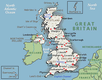 Europe and the seventh largest in the world. The second largest island of the British Isles is Ireland. It lies to the west of Great Britain. The larger part of Ireland is the Republic of Ireland. Northern Ireland, which occupies north-eastern part of the island, remains a part of the United Kingdom.
Apart from the land border with the Irish Republic, the United Kingdom is surrounded by sea. The UK lies between the North Atlantic Ocean and the North Sea, and comes within 35 km (22 miles) of the northwest coast of France, from which it is separated by the English Channel. The Irish Sea separates Great Britain from Ireland, while southwestern England, the northwestern coast of Northern Ireland, and western Scotland face the Atlantic Ocean. No part of Great Britain is more than 75 miles (120 km) from the sea. The seas surrounding the British Isles are rather shallow – less than 91 m because the islands lie on the continental shelf. The shallow waters are important because they provide excellent fishing grounds as well as breeding grounds for fish.
The most important sea routes pass through the English Channel and the North Sea linking Europe with America. The English Channel is 150 miles at its widest point and only 21 miles (34 km) at its narrowest. One can see the white cliffs of Dover from the French coast on a clear day. This may explain the origin of the old romantic name given to Britain – Albion. For centuries the Channel has been Britain’s defence against invaders. And it has also been the way to the Continent, a highway crowded with ships. The Channel Tunnel runs beneath the English Channel. It connects England and France and is used for both freight and passenger traffic. It was opened on May 6, 1994. It took 10 years to build it. There are two rail tunnels and a service and security tunnel each 50 km long. The tunnel is the largest undersea tunnel in the world.
The UK is a small country. The total area of the country is 94,526 square miles (244,820 sq. km). It is twice smaller than France or Spain.

