2015-05-26
 521
521A great range of plant and animal life characterizes the vast area of Canada, with its varied geographic and climatic zones. The flora of the Great Lakes–St. Lawrence region resembles that of the adjacent US section, with white pine, hemlock, sugar and red maples, yellow birch, and beech trees. Coniferous trees—particularly red spruce - predominate in the Maritime region, black spruce in the eastern Laurentian zone, white spruce in the western. In the east are also found the balsam fir, white cedar, tamarack, white birch, and aspen, with jack pine in the drier areas. From the prairie grassland to the Arctic tundra there are aspen, bur oak, balm of Gilead, cottonwood, balsam poplar, white birch, and other deciduous trees. Conifers dominate the northern section. Many types of grasses grow on the interior plains. The wet area along the west coast is famous for its tall, hard conifers: western hemlock and red cedar, Douglas fir, Sitka spruce, and western white pine. Subalpine forests cover the Rocky Mountain area, where there are such conifers as alpine fir, Engelmann spruce, lodgepole pine and aspen, and mountain hemlock. The great Arctic region is covered with low-growing grasses, mosses, and bushes.
The fauna of the Great Lakes–St. Lawrence region includes deer, black bear, opossum, gray and red squirrels, otter, beaver, and skunk; birds include eastern bluebird, red-winged blackbird, robin, wood thrush, woodpecker, oriole, bobolink, crow, hawk, bittern, heron, black duck, and loon. In the boreal forest area there are moose, caribou, black bear, lynx, timber wolf, marten, beaver, porcupine, snowshoe rabbit, red squirrel, and chipmunk. Typical mammals of the Rocky Mountain area are grizzly bear, mountain goat, moose, wapiti, cougar, and alpine flying squirrel. In the plains are rabbits, gophers, prairie birds, and waterfowl. Abundant on the west coast are deer, Cascade mountain goat, red squirrel, mountain beaver, various species of mice, and Puget striped skunk; common birds include northern Pigmy-owl, band-tailed pigeon, black swift, northern flicker, crow, rufous-sided towhee, and black brant. Over the stretches of the Arctic are the musk ox and reindeer, polar bear, caribou, white and blue fox, arctic hare, and lemming, as well as the snowy owl, ptarmigan, snow bunting, arctic tern, and other birds. Walrus, seals, and whales inhabit Canada's coastal waters.
Vocabulary notes
alpine - горный
aspen - осина
beaver - бобр
bittern - выпь
bobolink - рисовый трупиал (птица)
boreal – северный
caribou - карибу (северный канадский олень)
cedar - кедр
chipmunk – бурундук
cottonwood
cougar – пума, кугуар
deciduous – лиственный
flicker - дятел
hawk – ястреб
hemlock – болиголов крапчатый (растение)
heron - цапля
lemming – лемминг, пеструшка
loon - гагара
lynx - рысь
mammal - млекопитающее
marten - куница
moose – американский лось
oriole – иволга
porcupine - дикобраз
ptarmigan - белая куропатка
robin – малиновка
seal - тюлень
skunk – скунс
spruce – ель
swift – стриж
walrus - морж
wapiti - вапити (олень)
whale - кит
woodpecker - дятел
Ottawa
Ottawa is the capital of Canada and the country's fourth largest municipality, as well as the second largest city in the province of Ontario. It is located in the Ottawa Valley on the eastern edge of the province of Ontario, 400 kilometers (250 mi) north-east of Toronto and 190 kilometres (120 miles) west of Montreal. Ottawa lies on the banks of the Ottawa River, a major waterway that forms the boundary between Ontario and Quebec.
In 2005, the city was estimated to have 859,704 residents, while the metropolitan area, which includes the city of Gatineau, Quebec, was estimated to have a population of 1,148,785. Ottawa has a significant Francophone population, and under city government policy, all municipal services are available in both English and French. The current mayor of Ottawa is Larry O'Brien, who succeeded Bob Chiarelli on December 1, 2006. Ottawa has the highest per capita concentration of residents with PhDs (Doctor of Philosophy) in Canada.
On December 31, 1857, Queen Victoria was asked to choose a common capital for the then province of Canada (modern Quebec and Ontario) and chose Ottawa. There are old folk tales about how she made the choice: that she did so by sticking her hatpin on a map roughly halfway between Toronto and Montreal, or that she liked watercolours she had seen of the area. While such stories have no historical basis, they do illustrate how arbitrary the choice of Ottawa seemed to Canadians at the time. While Ottawa is now a major metropolis and Canada's fourth largest city, at the time it was a sometimes unruly logging town in the hinterland, far away from the colony's main cities, Quebec City and Montreal in Canada East, and Kingston and Toronto in Canada West.
In fact, the Queen's advisers had her pick Ottawa for three important reasons: first, it was the only settlement of any significant size located right on the border of Canada East and Canada West (Quebec/Ontario border today), making it a compromise between the two colonies and their French and English populations; second, the War of 1812 had shown how vulnerable the major cities were to American attack, since they were all located very close to the border while Ottawa was (then) surrounded by a dense forest far from the border; third, the government owned a large parcel of land on a spectacular spot overlooking the Ottawa River. Ottawa's position in the back country made it more defensible, while still allowing easy transportation via the Ottawa River to Canada East, and the Rideau Canal to Canada West.
Two other considerations were that Ottawa was at a point nearly exactly midway between Toronto and Quebec City (~500 km/310 mi) and that the small size of the town made it less likely that politically motivated mobs could go on a rampage and destroy government buildings, as had been the case in the previous Canadian capitals.
In 2001, the old city of Ottawa (estimated 2005 population 350,000) was amalgamated with the suburbs of Nepean (135,000), Kanata (56,000), Gloucester (120,000), Rockcliffe Park (2,100), Vanier (17,000) and Cumberland (55,000), and the rural townships of West Carleton (18,000), Osgoode (13,000), Rideau (18,000) and Goulbourn (24,000), along with the systems and infrastructure of the Regional Municipality of Ottawa-Carleton, to become one municipality. Ottawa-Carleton used to be just Carleton County before 1969 and consisted of what is now the City of Ottawa except for Cumberland.
Ottawa is home to a wealth of national museums, official residences, government buildings, memorials and heritage structures. Federal buildings in the National Capital Region are managed by the Public Works Canada, while most of the federal lands in the Region are managed by the National Capital Commission or NCC; its control of much undeveloped land gives the NCC a great deal of influence over the city's development.
Ottawa is home to a wealth of national museums, official residences, government buildings, memorials and heritage structures.
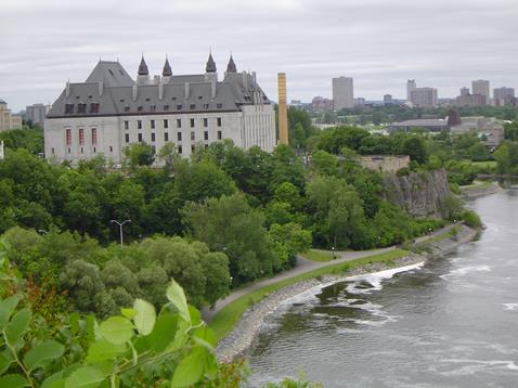
The Supreme Court of Canada viewed from Parliament Hill:
. 
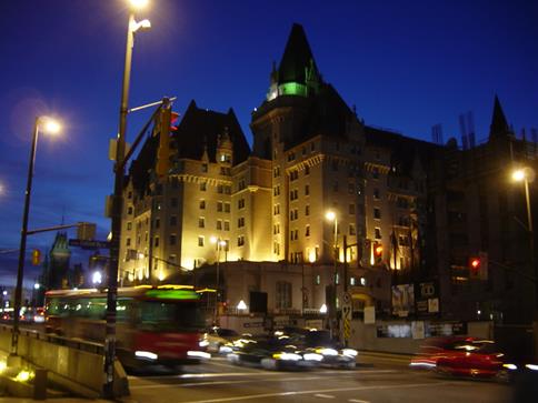
The Château Laurier in downtown Ottawa:
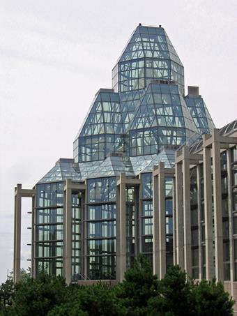
The glass façade of Canada's National Gallery:
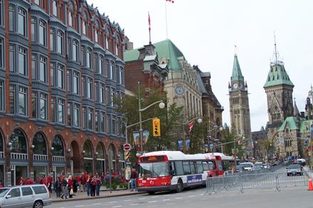
The historic buildings of Elgin Street, looking towards Parliament Hill:
Vocabulary notes
to go on a rampage – неистовствовать, прийти в ярость
hinterland - районы вглубь от границы; провинция, периферия
per capita (лат.) – на душу населения
prominent – известный, выдающийся, видный
spectacular – эффектный, захватывающий
vulnerable – уязвимый
waterway – водный путь