2020-08-05
 158
158| Таблица результатов | Средняя дистанция | Длинная Дистанция | Эстафета |
| Controls | Consistently technically difficult. | A mixture of technical difficulties. | A mixture of technical difficulties. |
| Route Choice | Small and medium scale route choice. | Significant route choice including some large-scale route choices. | Small and medium scale route choice. |
| Type of Running | High speed, but requiring runners to adjust their speed for the complexity of the terrain. | Physically demanding, requiring endurance and pace judgement. | High speed, often in close proximity to other runners who may, or may not, have the same controls to visit. |
| Terrain | Technically complex terrain. | Physically tough terrain allowing good route choice possibilities. | Some route choice possibilities and reasonably complex terrain. |
| Map | 1:10000 | 1:15000 | 1:10000 |
| Start Interval | 2 minutes | 3 minutes | Mass start |
| Timing | 1 second | 1 second | Mass start so the finish order is the order across the line. |
| 4.1 Middle Distance Rules Appendix 6: 2 MIDDLE DISTANCE |
| 2.1 The profile The Middle distance profile is technical. It takes place in a non-urban (mostly forested) environment with an emphasis on detailed navigation and where finding the controls constitute a challenge. It requires constant concentration on map reading with occasional shifts in running direction out from controls. The element of route choice is essential but should not be at the expense of technically demanding orienteering. The route in itself shall involve demanding navigation. The course shall require speed-shifts e.g. with legs through different types of vegetation. 2.2 Course planning considerations The course should be planned to allow competitors to be seen by spectators during the course of the race as well as when finishing. The start should be at the Arena and the course should preferably make runners pass the Arena during the competition. The demand on selection of Arena is subsequently high, providing both suitable terrain and good possibilities to make runners visible to spectators. Spectators are not allowed along the course except for parts passing the Arena (including controls at the Arena). |
The key features of a Middle Distance are:
· competitors are forced to demanding map reading right from the beginning
· different leg combinations with rhythmic changes will be provided
· decisive points are in the later parts of course, when physical stress starts to kick in
· decisive points near the competition centre when spectators and announcement increase pressure
· competitor needs to be fully alert and concentrate to navigation during the whole course
Planning courses that meet these features means that the Course Planner should identify the detailed areas allowing for difficult orienteering and areas well suited for challenging route choices. A route choice leg in Middle Distance should still be challenging to execute even after the route choice has been made. As a general rule, each control in a Middle Distance course should have an angle forcing the athlete to change direction at every control. When selecting legs in very detailed areas, care should be taken not to make the legs so short that one control becomes the attack point for the next.
“In the middle distance, there should be need for high concentration for map reading, complex terrain and lot of changes in direction, rhythm and technical demands.”
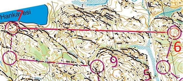
Miika Kirmula, FIN: In my opinion, the most interesting leg in year 2019 is from the Finnish WCup selection race middle distance 6-7 leg. This leg was directly after five short legs so there wasn’t so much time for perfect planning ahead. After making the bigger route choice you could win or lose A LOT with small micro route choices due to really steep parts and big cliffs. I missed the right choice and lost 22 seconds to the fastest split. I think it seemed like a risk to run a really steep slope descending to a lake and big cliffs in the end. However, the fastest split was made running the leg from the right.
 |
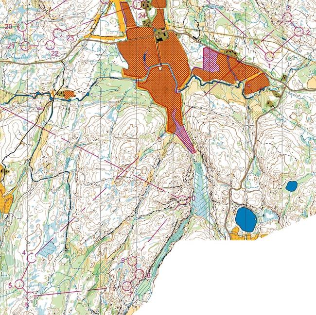
Magne Daehli, NOR: For the middle distance, I think the most important with a course is to serve challenging and intense orienteering. But also, here it’s important with some changes in terrain and/or type of legs, to break up the rhythm and forcing the runners to change their technique a bit.
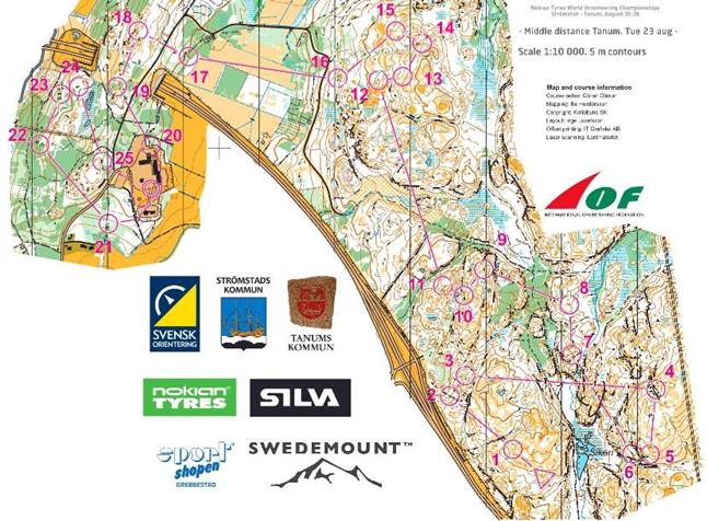
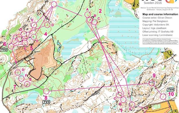
Example: WOC2016, Sweden
 |
| 4.2 Long Distance Rules Appendix 6: 3 LONG DISTANCE |
| 3.1 The profile The Long distance profile is physical endurance. It takes place in a non-urban (mostly forested) environment and aims at testing the athletes’ ability to make efficient route choices, to read and interpret the map and plan the race for endurance during a long and physically demanding exercise. The format emphasises route choices and navigation in rough, demanding terrain, preferably hilly. The control is the endpoint of a long leg with demanding route choice, and is not necessarily in itself difficult to find. The Long distance may in parts include elements characteristic of the Middle distance with the course suddenly breaking the pattern of route choice orienteering to introduce a section with more technically demanding legs. 3.2 Course planning considerations The course should be planned to allow competitors to be seen by spectators during the course of the race as well as when finishing. Preferably, the start should be at the Arena and the course should make runners pass the Arena during the competition. A special element of the Long distance is the long legs, considerably longer than the average leg length. These longer legs may be from 1.5 to 3.5 km |
Remarks related on section 3.2 above:
E.g. phi-loops give an alternative technique for breaking up runners. Butterflies with sharp angles may let runners see other runners more easily so they speed up, making this less worth as a spreading method. Some butterflies may even let runners approaching the centre control of the butterfly see runners leaving the butterfly. Also, phi-loops have less problems with sharp angles than butterflies.
In some case the butterflies/phi-loops have been followed by short legs instead of long legs – and in forest with good visibility. Continuing with a short leg after the butterfly increases the chance of regrouping of the same runners. One should ideally use a long leg straight after the spreading (butterfly or phi-loops), and if possible there should be low visibility at the start of the long leg straight after the butterfly helping them leave the phi-loop less obviously and therefore preventing followers from catching up.
The butterflies/phi-loops have not always been implemented in the most difficult terrain. Weak navigators tend to increase their speed in the butterfly in order to be able to catch up with the better runners up front. The risk for them making mistakes in tricky terrain in the spreading method is then increased. Also, low visibility in the area of the spreading method is an advantage.
In some case the course has started with short technical controls – increasing the chances for grouping
– followed by long legs. Long route choice legs often allow good runners to get away from followers but the reverse can be true if visibility in the terrain is good. A course could start with short leg(s) (for familiarising competitor to the map and terrain before long decisive leg) followed by long legs to avoid groups being formed early in the course.
The terrain chosen for the long distance has not always been optimal with regard to avoidance of groups formation. For optimal spreading, there should be distinctly different options on the long legs. However, this also often depends on the terrain and this should be taken into account when choosing terrain for high level IOF events Long distance races.
Butterflies have (sometimes) been too small. Short butterflies do not split packs while they only put constraints on the planning which again may lead to more packs due to fewer long legs and nothing gained by the butterflies.
Good terrain for the Long distance has characteristics that make runners lose eye contact with each other (such as denser vegetation, many hills/depressions etc.). Terrain with continuously good visibility is not ideal for high-level Long distance races. The terrain itself should be used as a break-up method
by putting the course through areas with limited visibility especially in the more difficult terrain where more skilled orienteers can disappear from potential followers. Spectators are not allowed along the course except for parts passing the Arena (including controls at the Arena).
Remarks related on section 3.3 above:
For WMOC the map scale is 1:10.000 and 1:7.500.
Key features of a Long Distance are:
· physically demanding requiring endurance and pace judgement
· multiple and decisive route choice legs demanding full concentration and commitment to decisions
· breaking up (or avoiding forming) groups somehow is important
· preferably no decisive route choice legs right from the starting point
· avoid short, technical controls / legs in the beginning to avoid grouping
· control point placement important, clearly readable
· decisive points in skill levels in later parts when physical elements are more important
· important where and when will refreshments offered, effect to route choices (rule 19.8)
Planning courses that meet these features means that the Course Planner should identify the detailed areas allowing for difficult orienteering and areas well suited for very long and challenging route choice legs. A route choice leg in Long Distance can be very long and is ideally still challenging to execute even after the route choice has been made. It is good practice to have a few shorter legs after a route choice leg in order to force the athlete to change technique (and possibly allow for a TV-sequence). In Long Distance courses, the most detailed areas, should be avoided.
Long legs are typically 10% to 15% of the overall course length and can sometimes be 20% if the terrain allows it. The same principles apply to WMOC Long courses, the difference being that lengths are scaled down to suit the shorter total course lengths.
Key features of a good route choice leg are:
· offers several (distinctly) different choices
· the best route choice may not be obvious at first sight
· runners on different route choices should lose sight of each other
· runners with different strengths should choose different routes
· time differences between the different routes should be big enough to be relevant (a good choice and execution should be rewarded)
· the easiest to execute route choice should in general not be the fastest overall
· orienteering during the leg still needs to be challenging on the fastest route (a fast route choice should not only be a road choice)
For the Long distance there should be varying terrain, varying speed and varying route choices. Also, varying orienteering techniques will be needed. In WOC2019, two of the legs covered about 40% of the whole course.
 |
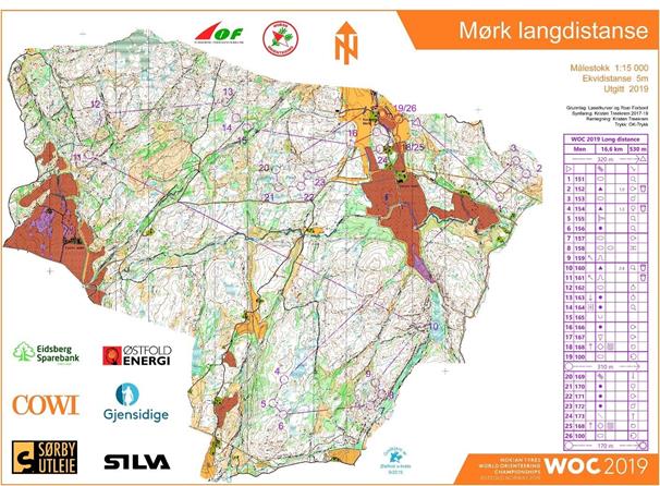 |
Tove Alexandersson, SWE: One of the most important details to make a Long distance course is some good longer legs. Preferably at least one leg that is over 1.5 km. To make it really good this leg should be a bit more complex than just straight or around, it’s good if there are some micro route choices also in the main route choice.
Example: O-Ringen 2019 E5, leg 10-11
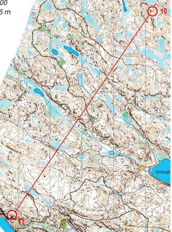 |
| 4.3 Relay Rules Appendix 6: 4 RELAY |
| 4.1 The profile The Relay profile is team competition. It takes place in a non-urban (mostly forested) environment. The format is built on a technically demanding concept, more similar to the concept of the Middle than the Long distance. Some elements characteristic of the Long distance, like longer, route-choice legs should occur, allowing competitors to pass each other without making contact. Good Relay terrain has characteristics that make runners lose eye contact with each other (such as denser vegetation, many hills/depressions etc.). Terrain with continuous good visibility is not suitable for the Relay. 4.2 Course planning considerations The Relay is a spectator friendly event in offering a competition between teams, head-to-head, and with the first to finish being the winner. The Arena layout and the course planning must consider this (e.g. when forking is used, the time difference between alternatives should be small). The competitors should, on each leg, pass the Arena, and if possible runners should be visible from the Arena while approaching the last control. An appropriate number of intermediate times (possibly with in-forest commentators) should be provided (as well as TV- controls shown on screen in the Arena). The mass start format requires a course planning technique separating runners from each other (e.g. forking). The best teams should be carefully allocated to different forking combinations. For fairness reasons the very last part of the last leg shall be the same for all runners. Spectators are not allowed along the course except for parts passing the Arena (including controls at the Arena). 4.3 The map The standard ISOM specification shall be followed. The map scale is 1:15.000 or 1:10.000. The decision on map scale shall be based on the complexity of the course design (e.g. short legs with controls close to each other may require the larger map scale). When 1:10.000 is used the terrain shall be mapped for 1:15.000 and strictly enlarged as specified by the ISOM. 4.4 Winning time, start interval and timing The winning time (the total time for the winning team) shall be 90-105 minutes for both the women’s relay and the men’s relay. Within the total time, the time for different legs may vary. No leg should be longer than 40 minutes or shorter than 30 minutes. The Relay is a mass start format and consists of three legs for both women and men. In WOC timing shall preferably be made by electronic means, but manual systems may be used. At the finish line there shall be photo-finish equipment to assist in judging the placings. |
Key features of a Relay are:
· team competition, all legs might be decisive
· high speed, often in close proximity to other runners
· based on the Middle distance concept with slightly fewer controls and more emphasis on route choice legs in the non-forked parts of the course
Planning courses that meet these features means that the Course Planner should identify the more detailed areas preferably with low visibility where to have forking. In Relay it is more important to have route choice legs than to have many controls in detailed areas. It is good to have forking crossings each other in order to stress the not so skilled athletes. Whereas forking may be in areas with low visibility, relays must also have legs in areas with very good visibility since this allows TV to show how widespread
the field is. Controls in such very visible areas may be slightly less difficult since the leading runners will otherwise be more easily caught up from behind.
Key features for good relay forking are:
· forking is introduced to force runners to do their own orienteering and not just follow those up front
· if possible, there should be a bit of a surprise element in the forking (not only 1 control in the forking)
· the different forking must be equally fast to run for runners of the same capacity
· it is ideal for different forking to have different best route choices
· practice shows that 3-5 forking per leg are optimal for a WOC Relay
· forking shall be understandable for the audience
· no forking in the last part of the last leg (head to head competition) for fairness reasons
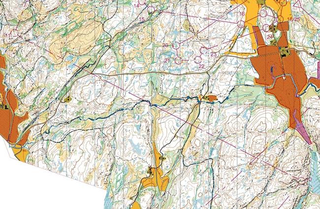
“In the relay, emphasis should be on route choice, varying terrain, various orienteering techniques and especially attractiveness for spectators. Fairness is mandatory.”
Example of good forking, WOC2016, Sweden
 |
Planning for TV and GPS
Further information about this may be found in the WOC Manual chapter 33 and the IOF TV Manual at https://orienteering.sport/iof/communication/
GPS tracking for events with TV coverage
During all World Class Events GPS-tracking must be offered. During the planning phase, the complete courses should be run through with a GPS-tracking unit of the type to be used in the competition to
(1) Find out if there are areas where mobile data coverage is poor as this has to be taken into account when planning TV-coverage where there are areas with poor mobile coverage. For individual start races this can be accounted for by not planning to show live GPS in these sections, see discussion below. For relay this can be accounted for by showing GPS with increased delay in these areas, but this has to be carefully planned, and ideally these areas should be avoided in the course-planning if possible.
(2) Find out if there are GPS-inaccuracies around any of the control points. If there are large inaccuracies around control points, i.e. if the GPS tracks do not go through the centre of the control point, this can be corrected for in some of the GPS-tracking software solutions for the TV-production.
When planning an interval-start forest competition format (Long or Middle), there will typically be two TV-sections for the Middle (ideally around 1/3 and 2/3 of the course) and three to four TV-sections for the Long (placement depends on where on the course the long route choice legs are, different approaches are possible). Specific sections of the course should be planned for showing GPS-tracking as “replay-to-live”, to be shown either ahead of or right after the TV-controls (see red circles in the
below figure). Poor mobile coverage may be (more) acceptable in the earlier parts of each of these GPS- areas. Preferably there should be at least 4-5 minutes of running from a route choice leg with special GPS-focus to a TV-control, but this is not critical if the terrain does not allow for it.
 |