2015-08-21
 6690
6690British studies
Describe the geographical position of the British Isles offering an explanation for its advantages and disadvantages. Define the term “continental shelf”, its importance for the economy.
The British Isles, which include Great Britain, Ireland and a lot of smaller islands, are situated off the north western coast of Europe and once formed part of that continent. They became islands when they were separated from it. The separation took place thousands of years ago, after the last Ice Age, when the ice melted, the level of the oceans rose and drowned the low-lying coastlands.
Politically the British Isles are divided into two countries - the United Kingdom of Great Britain and Northern Ireland, and the Irish Republic.
All in all there are over 5,000 islands in the system of the British Isles which are on the continental shelf, the zone of shallow water surrounding at present the continent and resembling a shelf above the deep water of the oceans.
The British Isles He between longitudes 2°E and 1TW and latitudes 50° and 6TN. Yet the country has a relatively mild climate throughout the year due to maritime influences. The warm waters of the North Atlantic Drift (Gulf Stream) move from the Gulf of Mexico and the Caribbean Sea across the Atlantic, and so reach the shores of Northwest Europe. That is why in winter the coasts are free of ice and the warm air passes over the British Isles throughout the year.
From the European continent the British Isles are separated by the English Channel and the North Sea.
The English Channel, in its widest part in the west is 220 km wide, and in the narrowest, what is called the Strait of Dover, only 32 km. So, the islands have had an easy and mainly Profitable contact with mainland Europe.
The most important sea routes pass through the English Channel and the North Sea linking Europe with the Americas and other continents.
The advantageous geographical position of Great Britain created favourable conditions for the development of shipping, trade and the economy as a whole.
However, the true value of Britain's geographical position has not always been obvious. Indeed, it clearly emerged in the late 15th and 16th centuries, a period which saw the discovery of America and the opening of the sea route round the Cape of Good Hope to the Far East.
Before this time European civilization had been centred in the Mediterranean lands.
The British Isles, although developing slowly, were on the margins of this civilization. With the discovery of the Americas the British Isles became an intermediary between Europe and the New World.
From the 16th century onwards, the wealth and influence of Great Britain increased rapidly.
With the acquisition of overseas colonies and the establishment of an empire she attained the status of a world power. Her position as such was emphasized by the Industrial Revolution of the 18th and 19th centuries, which was based on her resources of coal and iron and on the markets she had established throughout the world.
By Victorian times (1837-1901) Great Britain had become the richest country in the world, the first great modern industrial and capitalist society.
During the 20th century Britain lost this position and her economy faced increasing problems, especially with the collapse of the empire. The problems of supporting her population (60 million) on such a small land area (244,100 sq km) are also obvious. At the same time, however, it is important to remember that Britain, with the benefits of North Sea oil production, is still one of the leading industrial and trading countries in the world.
The British Isles, apart from Great Britain and Ireland, the two largest islands, include several other important islands and groups of islands. Off the northwestern coast of Great Britain there is a group of islands known as the Hebrides. They are separated from each other by the Sea of the Hebrides and the Little Minch. The main occupation of people here is farming combined with fishing.
Off the northern coast of Scotland, separated from the mainland by the stormy Pentland Firth are the Orkney Islands, comprising about a hundred islands.
The Shetland Islands are situated about 70 miles north of the Orkneys. They provide thin poor soils suitable only for rough pasture. The population (18,000) is actively engaged in herring-fishing. Apart from fish, the only exports from the islands are Shetland ponies and lace knitted from the wool of local sheep.
In the middle of the Irish Sea there is the Isle of Man (571 sq km). The island is administered by its own Manx Parliament and has a population of about 50,000 chiefly engaged in farming, fishing and tourist trade. The largest settlement is the holiday resort of Douglas.
Another important island in the Irish Sea is Anglesey, situated off the north coast of Wales. Anglesey contains only 52,000 people, and more of the working population are now engaged in industry than in fishing and agriculture. This is due partly to an increase in the tourist trade and partly to the introduction of several new industries, for example, the operation of the nuclear power station at Wylfa.
The Isle of Wight is in the English Channel. It is diamond-shaped, 40 km from west to east, and about half as much from north to south. The Isle of Wight lies across the southern end of Southampton Water, and is separated from the mainland by the Solent. With its sunny beaches and pleasant varied countryside, the island forms one of the most important tourist resorts. It is linked to London by ferry and rail services. Also lying in the English Channel off the extreme southwestern coast of Great Britain is a tiny group of the Isles of SciUy, another resort area.
The Channel Islands lie to the southwest on the French side of the English Channel. They are known to the French as the Isles Normandes. The Channel Islands form an archipelago, separated by shallow waters from northern France. As part of the Duchy of Normandy, they have been attached to the English Crown since the Norman Conquest (1066). The total area of the islands is only 194 sq km, but the population is over 130,000 what results in high density of population - 686 persons per sq km, In summer the population increases greatly by holiday- makers.
The chief islands of the group are Jersey and Guernsey. In rural areas many of the people speak a French-Norman dialect, but the official languages are English and French.
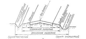
The British Isles are known for their greatly indented coastline. Therefore there are many bays and harbours, peninsulas and capes on Cornwall's rocky coast the coast, which were formed as a result of the raising and submerging of the land surface in the process of the geological development of the islands. Due to its extreme indentity the coastline of Great Britain, despite its relatively modest size, is 8,000 km long. Very much indented is the western coast, especially the coasts of Scotland and Wales.
The east coast is less lofty and more regular than the west coast, and the coastal lowlands are flooded frequently.
Hardly has anything been more important in British history than the fact that Great Britain is an island. Living on islands, and therefore near the sea, the inhabitants naturally grew into a nation of sailors. Their love of the sea led them to become navigators and discoverers of new lands in many parts of the globe.
The continental shelf plays an important role in Britain’s economy
The most important offshore oilfields are to be found off the coasts of eastern and northern Scotland and north-east England. By the 1990s over 40 fields produced oil, the largest of them being Brent, Forties, Ekofisk and others. The principal oil-producing area lies between the latitudes of the Tyne and Shetland Islands, but known to extend to the latitudes of Iceland. About two thousand kilometres of submarine pipeline have been built to bring ashore oil from the North Sea oilfields.
Today Great Britain is completely self-sufficient in oil but, in spite of this, the location of the oil refining industry still reflects the period when the country depended fully on imports. The principal refineries inevitably have coastal locations: Milford Haven, the Thames estuary, Southampton, Merseyside, Grangemouth, etc.
For many years gas was produced from coal and had important applications as fuel for domestic gas stoves and systems of central heating, in steel-making and in other industrial processes. In the 1960s, however, several discoveries of natural gas were made on the continental shelf off the east coast of Britain, in the bed of the North Sea. Natural gas usually occurs with petroleum, and much of the world output comes from oilfields. A large-scale offshore gas production in Britain began in 1967. To date home-produced natural gas accounted
MAIN OILAND GAS FIELDS IN THE NORTH SEA 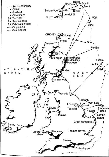 |
for about 80 per cent of total natural gas consumption, the remainder coming from Norway and Algeria. The North Sea gas from the continental shelf comes mainly from such major gasfields as Leman Bank, Hewett, Viking and others. The gas is being pumped ashore by pipelines laid on the seabed.
Like oil, natural gas is a valuable material for the chemical industry and demand for it is likely to increase considerably. Of all the major manufacturing industries, the chemical industry has shown the most rapid growth in recent years.
Give an account of the physical geography of the British Isles describing the varied relief features. Examine the main rivers and lakes of Great Britain, the climate and weather. Account for the chief mineral resources of Great Britain.
Waeather is not the same as climate. The weather at a place is the state of the atmosphere there at a given time or over a short period. The weather of the British Isles is greatly variable.
The climate of a place or region, on the other hand, represents the average weather conditions over a long period of time.
The climate of any place results from the interaction of a number of determining factors, of which the most important are latitude, distance from the sea, relief and the direction of the prevailing winds.
The geographical position of the British Isles within latitudes 50° to 61°N is a basic factor in determining the main characteristics of the climate.
Temperature, the most important climatic element, depends not only on the angle at which the sun's rays strike the earth's surface, but also on the duration of daylight. The length of day at London ranges from 16 hours 35 minutes on 21 June to 7 hours 50 minutes on 21 December.
British latitudes form the temperate nature of the British climate, for the sun is never directly overhead as in the tropical areas.
Britain's climate is dominated by the influence of the sea. It is much milder than that in any other country in the same latitudes. This is due partly to the presence of the North Atlantic Drift, or the Gulf Stream, and partly to the fact that north-west Europe lies in a predominantly westerly wind-belt. This means that marine influences warm the land in winter and cool it in summer. This moderating effect of the sea is in fact, the cause of the relatively small seasonal contrasts experienced in Britain.
The moderating effect of the ocean on air temperature is also stronger in winter than in summer. When the surface water is cooler than the air above it - as it frequently happens during the summer months - the air tends to lose its heat to the water. The lowest layers of air are chilled and become denser by contraction, and the chilled air tends to remain at low levels. The surface water expands because it is warmed, and remains on the surface of the ocean. Unless the air is turbulent, little of it can be cooled, for little heat is exchanged.
Opposite conditions apply in winter. The air in winter is likely to be cooler than the surface water, so that heat passes from water to air.
Air at low levels is warmed and expands and rises, carrying oceanic heat with it, while the chilled surface water contracts, and sinks, to be replaced by unchilled water from below. This conventional overturning both of water and of air leads to a vigorous exchange of heat.
The prevailing winds in the British Isles are westerlies. They are extremely moist, as a result of their long passage over the warm waters of the North Atlantic. On their arrival over Britain, the winds are forced upwards, and as a result large-scale condensation takes place, clouds form and precipitation follows, especially over the mountainous areas.
North and north-west winds often bring heavy falls of snow to north Britain during late October and November, but they are usually shortlived. Continental winds from the east sometimes reach the British Isles in summer as a warm, dry air-stream, but they are more frequently experienced in winter when they cross the North Sea and bring cold, continental-type weather to eastern and inland districts of Great Britain.
Relief is the most important factor controlling the distributio n of temperature and precipitation within Britain. The actual temperatures experienced in the hilly and mountainous parts are considerably lower than those in the lowlands. The effect of relief on precipitation is even more striking. Average annual rainfall in Britain is about 1,100 mm. But the geographical distribution of rainfall is largely determined by topography. The mountainous areas of the west and north have far more rainfall than the lowlands of the south and east.
The western Scottish Highlands, the Lake District (the Cumbrian mountains), Welsh uplands and parts of Devon and Cornwall in the south-west receive more than 2,000 mm of rainfall each year.
In contrast, the eastern lowlands, lying in a rain-shadow area, are much drier and usually receive little precipitation. Much of eastern and south-eastern England (including London) receive less than 700 mm each year, and snow falls on only 15 to 18 days on the average.